

2011 Geographies
InFuse simplifies the process of making selections from the wide range of different types of areas for which aggregate data values from the UK 2011 Census are produced by combining areas with equivalent functions and/or population sizes across all of the countries of the UK into composite Area Sets. For instance, Shire Districts, Metropolitan Districts, Unitary Authorities and London Boroughs in England are combined with Local Government Districts in Northern Ireland, Council Areas in Scotland and Unitary Authorities in Wales into a single Local Authorities area set with complete coverage of the UK. Some of the area sets have only partial coverage of the UK where equivalent areas do not exist across the whole UK.
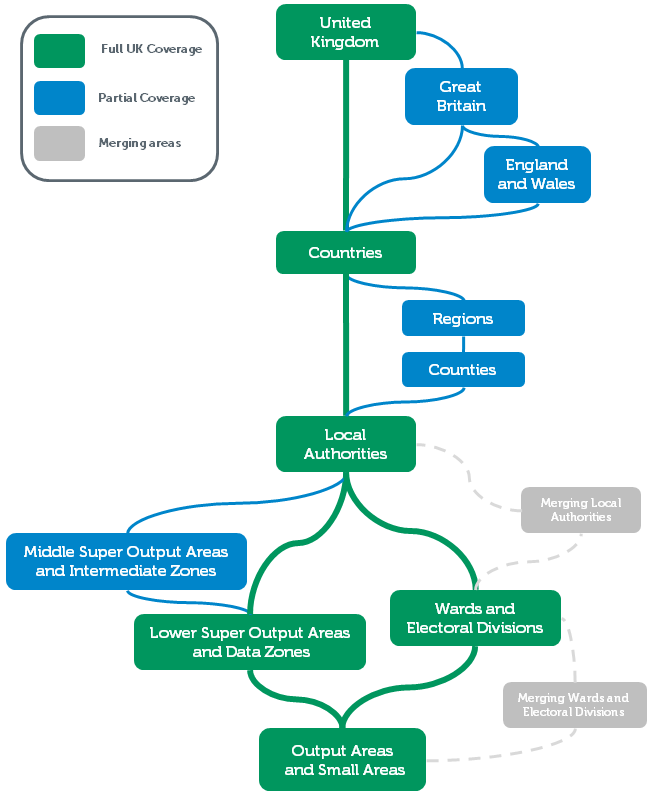
2011 census areas are mostly arranged in hierarchies in which one or more areas from a lower level are combined to form a single area in a higher level. For instance, ward areas can be combined to form local authority levels. The hierarchical relationships of the area sets are summarised in the diagram below. Area sets in green boxes have complete coverage of the UK, those in blue boxes have only partial coverage of the UK. Information about each of the geography sets can be revealed by hovering on the area set boxes. The boxes can also be clicked to jump to further information about the area sets below the diagram. The diagram will be expanded to incorporate additional geography sets, for instance workplace zones, as data for them is produced and processed to be made available via InFuse.
It’s important to be aware that values from some of the 2011 census characteristics will not be produced for all of the 2011 census areas. For instance, many of the most detailed characteristics will not be produced for the smallest Output Areas and Small Areas because they would result in small values with a potential to disclose personal information about identifiable individuals. In addition, some values that will be produced are not yet available due to the staged production 2011 census aggregate outputs over several years. Although InFuse is designed to guide users to only make selections of combinations of characteristics and areas for which values are available, it’s still possible to obtain data from InFuse that contains some gaps where no values are available for particular combinations.
Area Lists are provided for each area set. These provide lists of the names (called labels in data files) and unique Area Identifiers for all of the areas in each area set. Area identifiers are important because there are many areas that share names. For instance, there are 26 areas with the name Central across the UK in the wards and electoral divisions area set. The two types of identifiers provided are the official GSS (Government Statistical Service) identifiers, and internal InFuse area identifiers. A combined area lists spreadsheet is also provided.
An All Area Lookup is also provided. This provides information on the hierarchical relationships between each area in the area set and the areas in all higher-level area sets.
Digital boundary data (DBD) corresponding to the InFuse area sets is available from Easy Download for mapping and spatial analysis.
United Kingdom
A single area with complete coverage of the United Kingdom (England, Northern Ireland, Scotland and Wales combined).
| Area ID | Area Label |
|---|---|
| K02000001 | United Kingdom |
Boundaries for United Kingdom:
Great Britain
A single area with complete coverage of Great Britain (England, Scotland and Wales combined).
| Area ID | Area Label |
|---|---|
| K03000001 | Great Britain |
Boundaries for Great Britain:
England and Wales
A single area with complete coverage of England and Wales combined.
| Area ID | Area Label |
|---|---|
| K04000001 | England and Wales |
Boundaries for England and Wales:
Countries
The Countries area list contains four areas for the countries of England, Northern Ireland, Scotland and Wales, and provides complete coverage of the United Kingdom.
| Area ID | Area Label | Area Type |
|---|---|---|
| E92000001 | England | Country |
| N92000002 | Northern Ireland | Country |
| S92000003 | Scotland | Country |
| W92000004 | Wales | Country |
Boundaries for Countries:
Regions
The Region area list contains nine areas for English Regions, and provides complete coverage of England only.
| Area ID | Area Label | Area Type | Country |
|---|---|---|---|
| E12000001 | North East | Region | England |
| E12000002 | North West | Region | England |
| E12000003 | Yorkshire and The Humber | Region | England |
| E12000004 | East Midlands | Region | England |
| E12000005 | West Midlands | Region | England |
| E12000006 | East of England | Region | England |
| E12000007 | London | Region | England |
| E12000008 | South East | Region | England |
| E12000009 | South West | Region | England |
Boundaries for Regions:
Counties
The Counties area list contains 35 areas of the following constituent English geographies:
- 27 Shire counties.
- 6 Metropolitan counties.
- Inner London and Outer London.
The Counties area list provides partial coverage of England only. Gaps in the coverage of England are due to the absence of English Unitary Authorities from this set. English Unitary Authorities are contained in the Local Authorities area list.
Boundaries for Counties:
Local Authorities
The Local Authorities area list contains 404 areas of the following constituent geographies:
- 36 Metropolitan Districts in England.
- 201 Non-metropolitan Districts in England.
- 31 London Boroughs in England.
- 54 Unitary Authorities in England.
- 26 Local Government Districts in Northern Ireland.
- 32 Council Areas in Scotland.
- 22 Unitary Authorities in Wales.
- 2 Census Merged Districts* in England.
The Local Authorities area list provides complete coverage of the United Kingdom.
Boundaries for Local Authorities areas:
* Four census districts (1% from a total of 406) were subject to merging to form the two census merged districts in the District Set. A separate Merging Census Districts Set contains only these census districts. Lower threshold aggregate outputs are available for the merging census districts, but not higher threshold aggregate outputs. The area lists below also identify the census merged districts to which the census districts were merged.
Boundaries for Merging Local Authorities areas:
Wards and Electoral Divisions
The Wards and Electoral Divisions list contains 9,481 areas of the following constituent geographies:
- 7218 Census Wards in England
- 453 Census Electoral Divisions in England
- 7 Census Merged Wards* in England
- 582 Census Wards in Northern Ireland.
- 353 Census Wards in Scotland.
- 856 Census Electoral Divisions in Wales.
- 12 Census Merged Wards* in Wales.
The Wards and Electoral Divisions area list provides complete coverage of the United Kingdom.
- Wards and Electoral Divisions area list (XLSX fornat)
- Wards and Electoral Divisions area list (CSV format)
Boundaries for Wards and Electoral Divisions:
* Forty-three census wards and census electoral divisions (0.5% from a total of 9505) were subject to merging to form the 19 census merged wards in the Wards and Electoral Divisions area list. A separate Merging Wards and Electoral Divisions area list contains only these census wards. Lower threshold aggregate outputs are available for the merging census wards, but not higher threshold aggregate outputs. The area lists below also identify the census merged wards to which the census wards were merged.
- Merging Wards and Electoral Divisions area list (XLSX fornat)
- Merging Wards and Electoral Divisions area list (CSV format)
Boundaries for Merging Wards and Electoral Divisions:
Middle Layer Super Output Areas and Intermediate Zones
The Middle Super Output Areas and Intermediate Zones area list contains 8,480 areas of the following constituent geographies:
- 6,791 Middle Super Output Area Set in England.
- 1,279 Census Intermediate Zones in Scotland.
- 410 Middle Super Output Area Set in Wales.
This list provides complete coverage of Great Britain only.
- Middle Layer Super Output Area and Intermediate Zones list (XLSX fornat)
- Middle Layer Super Output Area and Intermediate Zones list (CSV format)
Boundaries for Middle Super Output Areas and Intermediate Zones:
Lower Layer Super Output Areas and Data Zones
The Lower Super Output Areas and Data Zones list contains 42,619 areas of the following constituent geographies:
- 32,844 Lower Super Output Areas in England
- 890 Super Output Areas in Northern Ireland
- 6,976 Census Data Zones in Scotland
- 1,909 Lower Super Output Areas in Wales
The list provides complete coverage of the United Kingdom.
- Lower Super Output Areas and Data Zones list (XLSX fornat)
- Lower Super Output Areas and Data Zones list (CSV format)
Boundaries for Lower Super Output Areas and Data Zones:
Output Areas and Small Areas
The Output Areas and Small Areas list contains 232,296 areas of the following constituent geographies:
- 171,372 Output Areas in England
- 46,351 Output Areas in Scotland
- 4,537 Small Areas in Northern Ireland
- 10,036 Output Areas in Wales
The list provides complete coverage of the United Kingdom.
Boundaries for Output Areas and Small Areas:
All Area Lists and Area Lookups
- All areas list (XLSX fornat)
- All areas lookup in xlsx format (zipped)
- All areas lookup in csv format (zipped)